Types of Precipitation Formation Processes

Although moisture is always present in the atmosphere it is condensed only when air is cooled and saturated with some water vapors. Usually, the mechanism by which air is cooled to cause precipitation is the lifting of the air mass.
Based on the lifting of air-carrying vapors, precipitation is classified as follows:
- Cyclonic Precipitation
- Convective Precipitation
- Orographic Precipitation
- Frontal Precipitation
- Freezing Precipitation
- Snowfall Precipitation
- Graupel and Hail Precipitation
1. Cyclonic Precipitation
Definition
Cyclone is a type of atmospheric disturbance by a mass of air circulating clockwise in the southern and anticlockwise in the northern hemispheres. Cyclonic precipitation is associated with the presence of cyclones or low-pressure systems. These systems typically have counterclockwise rotation in the Northern Hemisphere (clockwise in the Southern Hemisphere). As warm, moist air is drawn into the cyclone and rises, it cools and condenses, leading to cloud formation and precipitation. Cyclonic precipitation is associated with the presence of cyclones or low-pressure systems. These systems typically have counterclockwise rotation in the Northern Hemisphere (clockwise in the Southern Hemisphere). As warm, moist air is drawn into the cyclone and rises, it cools and condenses, leading to cloud formation and precipitation.
Characteristics of Cyclonic Precipitation
- Formation: Cyclonic precipitation is associated with the presence of cyclones or low-pressure systems. These systems have counterclockwise rotation in the Northern Hemisphere (clockwise in the Southern Hemisphere). As warm, moist air is drawn into the cyclone and rises, it cools, leading to cloud formation and precipitation.
- Duration and Intensity: Cyclonic precipitation can last for an extended period, often spanning several days, as cyclones typically move relatively slowly. The intensity of precipitation can vary, ranging from light to moderate rainfall over a broad area to heavy rainfall associated with the cyclone's center.
- Distribution: Cyclonic precipitation is widespread and covers a large area, extending well beyond the center of the cyclone. The highest rainfall amounts are often found in the cyclone's vicinity, particularly in the forward quadrant in the direction of its movement.
What causes Cyclonic Type of Precipitation
- Cyclone is also a violently rotating wind storm.
- It is a large whirling mass all converging into a low-pressure area, air will flow horizontally from the surrounding area, causing air in the low-pressure area to lift. The precipitation that results is called non-frontal cyclonic precipitation.
- If one air mass passes over another air mass, the precipitation is frontal cyclonic precipitation.
- The air rushes horizontally into the low-pressure area changing into a whirling mass because of the rotary motion of the earth about its own axis. This cyclone is a very large mass of air ranging from 800 to 1600km in diameter and moving with a velocity of 50 km/hr.
- Cyclonic precipitation occurs in the form of drizzle, intermediate rain, or steady rain.
- Precipitation caused by the cold front is intense and of short duration.
- Precipitation caused by the warm front is more continuous.
2. Convective Precipitation:
Definition
Convective precipitation occurs when warm, moist air rises rapidly in unstable atmospheric conditions. As the air rises, it cools, causing water vapor to condense and form clouds. Eventually, the condensed water droplets or ice crystals grow larger and fall as precipitation, such as rain or hail, due to gravity. It is due to the upward movement of warm air. Generally, this type of precipitation occurs in tropical regions, where on hot days, the ground surface is heated unequally, causing the warmer air to lift up as the colder air comes to take its place. The vertical air currents develop tremendous velocities and are dangerous for aircraft.
Characteristics of Convective Precipitation
- Formation: Convective precipitation occurs when warm, moist air rises rapidly in unstable atmospheric conditions. As the air rises, it cools, leading to condensation and the formation of clouds. Eventually, the condensed water droplets or ice crystals grow larger and fall as precipitation due to gravity.
- Duration and Intensity: Convective precipitation events are often short-lived but can be intense. They can result in heavy rainfall, thunderstorms, and even severe weather phenomena such as lightning, strong winds, and hail.
- Distribution: Convective precipitation is typically localized and sporadic, occurring in isolated cells or clusters. It can exhibit high spatial and temporal variability, with rainfall rates varying significantly within a small area.
- Precipitation occurs in the form of showers of high intensities and short duration،
- In summer most parts of Pakistan get this type of precipitation.
3. Orographic precipitation:
Definition
Orographic precipitation is associated with the lifting of moist air as it encounters a barrier, such as a mountain range. As the air is forced to rise over the mountain, it cools and releases moisture, leading to cloud formation and precipitation on the windward side of the mountain. The leeward side may experience a rain shadow effect, resulting in drier conditions. This type of precipitation is caused by air masses striking some natural topographic barriers like mountains. As it cannot move forward it rises up causing condensation and precipitation.
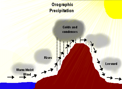 Characteristics of Orographic Precipitation
- Formation: Orographic precipitation occurs when moist air is forced to rise over elevated terrain, such as mountains. As the air rises, it cools, leading to condensation and the formation of clouds. Eventually, the condensed water droplets or ice crystals grow larger and fall as precipitation on the windward side of the mountain.
- Distribution: Orographic precipitation is typically localized and concentrated on the windward side of the mountain or hill. The leeward side may experience a rain shadow effect, resulting in drier conditions.
- Intensity and Duration: Orographic precipitation can be intense, particularly if the air mass is moist and the mountain range is significant. The intensity and duration of orographic precipitation depend on factors such as the height and orientation of the mountains, the prevailing wind direction, and the characteristics of the air mass.
- The greater amount of precipitation falls on the windward side.
- Orographic barriers tend to increase both cyclones and orographic precipitation because of the lifting of air.
- Rainfall is composed of steady rainfall.
- The southern slope of the Himalayas is a good example of this kind.
- Similarly, winds coming from the ocean strike the western slopes of coastal ranges causing heavy rains.
- All three types of precipitations occur due to the lifting of air.
Frontal Precipitation
Frontal precipitation occurs along the boundaries between air masses with different characteristics, such as temperature and moisture content. When a warm air mass meets a cold air mass, the warm air is forced to rise over the colder air. As the warm air cools, water vapor condenses and forms precipitation along the frontal boundary.
Characteristics of Frontal Precipitation
- Formation: Frontal precipitation occurs along the boundaries between air masses with different characteristics, typically a warm front and a cold front. The warm air rises over the denser cold air, leading to the formation of clouds and precipitation.
- Duration and Intensity: Frontal precipitation can last for several hours or even days, depending on the speed at which the front moves. It often exhibits steady and continuous rainfall or snowfall, with moderate to high intensity.
- Distribution: Frontal precipitation is typically widespread and covers a large area along the frontal boundary, extending for hundreds of kilometers. The intensity of precipitation is generally highest in the vicinity of the front.
- Types of Precipitation: Frontal precipitation can produce various types of precipitation, including rain, freezing rain, sleet, or snow, depending on the temperature profile of the atmospheric layers through which the precipitation passes.
Freezing Precipitation:
Freezing precipitation occurs when raindrops or melted snowflakes encounter a subfreezing layer of air near the surface. The supercooled water droplets freeze upon contact with objects, such as the ground, trees, or power lines, forming freezing rain. Freezing rain can create hazardous conditions, as it can accumulate as a layer of ice on surfaces.
Characteristics of Freezing Precipitation
- Formation: Freezing precipitation occurs when raindrops or melted snowflakes encounter a subfreezing layer of air near the surface. The supercooled water droplets freeze upon contact with objects, such as the ground, trees, or power lines, forming a layer of ice.
- Types: The two primary types of freezing precipitation are freezing rain and freezing drizzle. Freezing rain occurs when supercooled water droplets freeze upon contact with surfaces, forming a clear and smooth layer of ice. Freezing drizzle refers to supercooled water droplets that freeze into small ice pellets or rime ice upon contact with surfaces.
- Hazardous Conditions: Freezing precipitation can create hazardous conditions, as the ice coating on surfaces can make them slippery, resulting in dangerous driving and walking conditions. Accumulations of ice on trees and power lines can lead to disruptions, such as power outages and falling tree branches.
Snowfall:
Snowfall is the result of the direct crystallization of ice from the atmosphere. When water vapor condenses at temperatures below freezing, it forms ice crystals that join together to form snowflakes. Snowflakes then fall to the ground without melting, resulting in snow accumulation.
Characteristics of Snowfall Precipitation
- Formation: Snowfall occurs when water vapor in the atmosphere directly crystallizes into ice without going through the liquid phase. This process is known as deposition. Snowflakes form as ice crystals grow through the aggregation of water vapor molecules onto a nucleus, such as a dust particle or an ice crystal.
- Crystal Structure: Snowflakes exhibit intricate and unique crystal structures due to variations in temperature, humidity, and atmospheric conditions during their formation. They can have various shapes, including hexagonal plates, dendrites (branch-like structures), columns, and needles.
- Intensity and Accumulation: The intensity of snowfall can vary, ranging from light and flurries to heavy and intense snowfall. Snow accumulation on the ground can vary widely, depending on the duration and intensity of the snowfall, as well as factors like temperature and wind.
- Snow-to-Water Ratio: The snow-to-water ratio refers to the amount of snow that is equivalent to a given amount of liquid water. It varies depending on snow density, which is influenced by factors such as temperature and wind. Light, fluffy snow has a higher snow-to-water ratio, while wet, heavy snow has a lower ratio.
Graupel and Hail:
Graupel and hail are forms of precipitation that involve the growth of ice pellets or hailstones within convective storms. Graupel forms when supercooled water droplets freeze onto ice crystals, forming small, opaque ice pellets. Hail is formed in severe thunderstorms when updrafts carry raindrops upward into extremely cold regions of the storm, causing layer upon layer of ice to build up on the hailstone until it becomes too heavy to be supported by the updraft and falls to the ground.
Characteristics of Graupel
- Formation: Graupel is formed when supercooled water droplets freeze onto ice crystals. These ice pellets are opaque and have a soft, irregular structure.
- Appearance: Graupel appears as small, white ice pellets with a diameter of about 2-5 mm. It is often described as resembling small Styrofoam balls or soft hail.
- Conditions: Graupel is typically associated with convective storms and thunderstorms that have strong updrafts. It forms when there are supercooled water droplets and ice crystals present in the storm cloud.
Hail
Characteristics of Hail
- Formation: Hail is formed in severe thunderstorms characterized by strong updrafts. Raindrops are carried upward into extremely cold regions of the storm, where they freeze onto ice nuclei. These ice nuclei are then carried by the updrafts, accumulating layers of ice and growing in size until they become too heavy to be supported and fall to the ground as hailstones.
- Size and Structure: Hailstones can vary in size, ranging from small pea-sized hail to large grapefruit-sized hailstones. They typically have layered structures, with alternating layers of clear and opaque ice.
- Conditions: Hailstorms are associated with severe convective storms that have strong updrafts and intense thunderstorm activity. The presence of an updraft capable of supporting the growth of hailstones is crucial for their formation.
These precipitation formation processes are influenced by atmospheric conditions, including temperature, humidity, air stability, and wind patterns. Understanding these processes is essential for predicting and studying precipitation patterns, which are crucial for various applications such as agriculture, water resource management, and climate studies.