Chain Survey Steps - Method for Performing Chain Surveying
Chain survey is the simplest method of surveying. In this survey only measurements are taken in the field, and the rest work, such as plotting calculation etc. are done in the office. This is most suitable adapted to small plane areas with very few details. If carefully done, it gives quite accurate results. The necessary requirements for field work are chain, tape, ranging rod, arrows and sometime cross staff.
Classification and Types of Civil Engineering Survey
Topographical Survey: Degree of accuracy is comparatively low. American survey put 250 km2 for treating survey as Plane, but controlling factor should be degree of precision rather than extent of area. Cadastral Survey: Details such boundaries of houses, town, fields and other properties pathways are determined. Engineering Survey can be further divided into:
Types of Chains and Tapes in Civil Survey
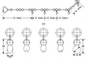
Following are the various types of chain in common use: Metric chains Steel band or Band chain Gunter's chain or surveyors chain Engineers chain Revenue chain Metric chains are made in lengths 20m and 30m. Tallies are fixed at every five-meter length and brass rings are provided at every meter length except where tallies are attached. Length = 66’ (22 yards), No of links = 100
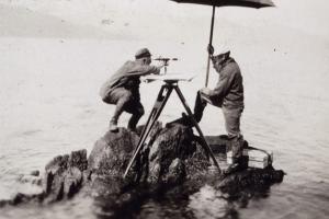
Video on Method of Terrestrial Photogrammetry
The principal is exactly similar to plan table surveying, it may be stated as “The position of the object with ref to the base line is given by the intersection of the rays drawn to it form each end of the base line” In plane tabling most of the work is executed in the field while in this method it is done in the office.
Surveying Dictionary Words Definitions Starting from T, U, V, W, X, Y, Z
A tape is a flexible device used for measuring linear distances. There are tapes made of many materials, such as cloth, kevlar, steel, and invar. The most common tape used by surveyors is the steel tape. Standard lengths are 100 feet (for English unit surveys) or 30 meters (for SI unit surveys). Tapes are usually marked at every foot or meter. At the ends of the tape, there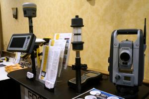
Maintenance of Surveying Equipment - Routine Care and Transportation
Surveying equipment is being used under most stressful conditions. The equipment is exposed to extreme weather conditions, used in dusty construction areas and is subject to bumpy transportation. Proper care in the method by which equipment is used, stored, transported, and adjusted is a major factor in the successful completion of the survey. Lack of good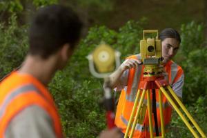
What is the Definition of Territorial Survey?
It is the type of survey in which the study of Physical features, topographical features, atmosphere, contours, soil types and water resources of the area is done. Related Surveys: River Survey Photogrammetric Survey Geodetic Survey Tunnel Survey It is the type of survey in which the study of Physical features, topographical features, atmosphere, contours, soil types and water resources of the area is done.
Types of Survey and Classification of Surveying
Surveying is indispensable to a number of human endeavor, which use surveying principles and practice to their required areas of application. The types of surveying and application are identified and explained below: 1. ALTA / ACSM survey 2. Archaeological survey 3. Agricultural development survey 4. As-built survey 5. Bathymetric survey 6. Construction survey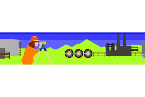
Methods of Locating New Stations in Surveying - Ranging and Chaining
In surveying relative position of points are located by measurement from at least two points of reference, whose positions must be known already. Ranging is process of establishing Intermediate points on straight line between the terminal points or stations. Two methods can be employed depending on the intervisibility : Direct Ranging, Indirect Ranging: It Is usedStereoscopy - Stereoscope and Types of Stereoscope
It is defined as observing the object in SD, a process requiring a person to have normal binocular vision. A person with vision in only one eye can not see stereoscopically. If figure two eyes are separated y a distance ‘b’ called eye base or intraocular distance (65mm or 2.6//). Combined image of a and as seen left and eyes appear to fuse at ‘M’ while images of b and
Site Setting Out Survey | Field Setting Out | Surveying Layout
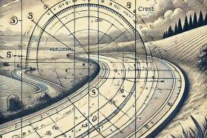
The method of setting out is the reverse of surveying process. The process involves the positions and levels of building lines and road alignments shown on the construction plans to be established on the ground by various techniques and instruments. A building can be set out by taking referencing from an already established baseline. An irregular building or a buildingReverse or Ogee Curve - Definition and Making
Combination of two or more simple circular curves of different radius having their curvature in the same direction. Essentially, a compound curve consists of two curves that are joined at a point of tangency and are located on the same side of a common tangent. Though their radii are in the same direction, they are of different values. This is the process of establishing
Surveying Dictionary Words Definitions Starting from Q, R, S
Query: The process of selecting features in a database. Can be achieved through a query language directly on the data or, in a GIS, by interactively selecting features. Raasterization: The process that converts vector data, which is a series of points, lines and polygons into raster data which is a series of cells with a discrete value. Railroads: A category of rural transportation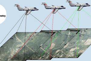
Principal Method of Terrestrial Photogrammetry
The principal is exactly similar to plan table surveying, it may be stated as “The position of the object with ref to the base line is given by the intersection of the rays drawn to it form each end of the base line” In plane tabling most of the work is executed in the field while in this method it is done in the office. The principal is explained as follows: C and D = Camera