What are Survey Stations and How to Select a Survey Station

Definition
Survey Stations are a point of importance at the beginning and end of the chain line. In surveying, a survey station refers to a specific point or location that is chosen as a reference or control point for conducting measurements and establishing spatial relationships. Survey stations are typically marked or identified in the field to facilitate future surveys or to serve as benchmarks for geodetic control. They play a crucial role in determining the coordinates, elevations, and distances of other points in the survey area.
There are two main types of survey stations:
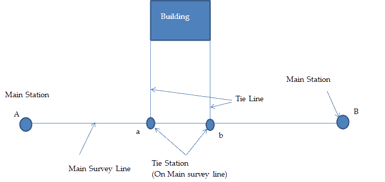
Main Station
- These are the end of the survey line i.e. which connects boundaries.
- The line joining the Main Stations is called Main Survey Line or Chain Line.
- They are represented by Circle, Capital letters A B... Or numbers 1 2... Or (A)
Subsidiary or Tie Station
- These are the points selected on the main line, where it is necessary to run auxiliary lines to locate interior details such as corners, trees, buildings, etc.
- Lines joining tie stations are called Tie Lines or Subsidiary Lines
- They are represented by Small letters a, b,
Other Types of Survey Stations
Here are the types of survey stations commonly used:
Control Stations:
Control stations are established to provide known and accurate reference points for the survey. These stations serve as the foundation for the survey network and are typically marked with permanent monuments or markers. Control stations are precisely measured and tied to established geodetic control systems or coordinate systems. They are used to establish the coordinates and elevations of other points in the survey area.
Benchmarks:
Benchmarks are specific types of control stations that are used to determine precise elevations. They are typically points with known elevations above a reference datum, such as a local or national vertical datum. Benchmarks are used to establish elevations of other points or features in the survey, such as the ground surface or structures. They are often marked with metal disks or plaques set in concrete or rock.
Reference Stations:
Reference stations are survey stations that are used to provide reference data or observations for ongoing monitoring or real-time positioning. They are typically equipped with advanced surveying instruments such as GPS receivers or total stations. Reference stations serve as fixed points to which other measurements or observations can be compared or corrected.
Temporary Stations:
Temporary stations are established for specific survey projects and are typically used for short-term measurements. They are marked or identified temporarily during the survey but may not have permanent physical markers. Temporary stations may be established for topographic surveys, construction layouts, or other specific survey tasks.
Turning Points:
Turning points are survey stations that are used to change the direction or orientation of survey lines. They are often established at specific locations where the surveyor needs to change direction or set up new instrument stations. Turning points are commonly marked with wooden stakes or temporary markers.
Occupied Stations:
Occupied stations are survey stations where survey instruments, such as total stations or GPS receivers, are set up to measure angles, distances, or other survey data. These stations are occupied by the surveyor during the surveying process and are often chosen for their visibility, stability, and accessibility.
The selection and establishment of survey stations depend on factors such as the survey objectives, accuracy requirements, terrain conditions, and project specifications. Professional surveyors carefully choose and document survey stations to ensure accurate and reliable survey measurements.
Factors Affecting the Selection of Survey Station
Selecting a survey station involves careful consideration of various factors to ensure accurate and reliable measurements. Here are some steps to help guide the process of selecting a survey station:
Determine Survey Objectives:
Clarify the purpose of the survey and the specific measurements or data you need to collect. This will help determine the requirements for the survey station, such as its location, accessibility, and environmental conditions.
Define Survey Area:
Identify the area or region where the survey will be conducted. Consider the size of the area, its topography, and any specific features or points of interest that need to be included in the survey.
Assess Accessibility:
Evaluate the accessibility of potential survey stations. Consider factors such as proximity to transportation routes, availability of roads or trails, and the ease of reaching the station with survey equipment and personnel. Accessibility is crucial for conducting fieldwork efficiently.
Consider Line of Sight:
Ensure that the survey station has an unobstructed line of sight to the targets or points that need to be measured. If the survey requires sighting to other stations or landmarks, verify that there are no obstructions, such as buildings, trees, or hills, that could hinder visibility.
Evaluate Stability:
Assess the stability of the survey station. Look for a location that provides a solid and stable foundation for the survey equipment. Avoid areas prone to erosion, landslides, or other factors that could affect the stability of the station.
Account for Environmental Conditions:
Consider the environmental conditions that may impact the survey measurements. Factors such as wind, temperature, humidity, and vegetation can affect the accuracy of measurements. Choose a location that minimizes the influence of these factors or take appropriate measures to account for their effects.
Check Geodetic Control:
Consult geodetic control data, such as established control points or benchmarks, in the survey area. Look for nearby control points that can be used as references to tie the survey station to a known coordinate system. This helps ensure the accuracy and compatibility of the survey data with existing geodetic frameworks.
Utilize Existing Infrastructure:
If possible, take advantage of existing infrastructure or structures that can serve as stable and accessible survey stations. Examples include buildings, towers, bridges, or monuments that provide a suitable platform for surveying instruments.
Consider Future Use:
Anticipate future needs and potential survey expansions. Select a survey station that can accommodate future survey requirements and provide a foundation for possible expansion or follow-up surveys.
Document and Record:
Maintain detailed documentation of the selected survey station, including its location, description, and any relevant observations or considerations. This information is crucial for reference and documentation purposes throughout the surveying process.
It is essential to consult with experienced surveyors or geospatial professionals who have knowledge of the specific surveying techniques and requirements for your project. Their expertise can provide valuable insights and ensure that the chosen survey station meets the necessary criteria for accurate and reliable measurements.
The following points should be kept in mind while selecting a station:
- The stations should be mutually inter-visible
- The main principle of chain survey should strictly be observed
- If possible, a line through the whole length of the area should be drawn
- All triangles should be well defined
- A check line should be provided in each triangle
- Survey lines should be as few as possible
- A number of tie lines should be drawn
- The position of survey lines should be such that to avoid obstacles to chaining and ranging
- It should be on level ground
- The sides of the triangle should pass as close to the boundary as possible.
Important Lines
- Baseline
- Check line
- Tie line
Also See: Types of Surveying Chains
Base Line
A base line is a long and precisely measured line used as a reference for other survey measurements. It serves as a fundamental element in many surveying projects, providing a known distance and direction. Base lines are typically measured with high accuracy using advanced surveying instruments such as total stations or GPS equipment. They establish the foundation for trigonometric or geometric calculations used to determine the positions of other points or features in the survey area.
- The longest of the chain lines used in making a survey is generally regarded as Baseline.
- It is the most important line because it fixes up the direction of all other lines, since on baseline, is built framework of a survey.
- It should be laid on level ground, as possible through the center and length of the area.
- It should be correctly measured and should be measured twice or thrice.
Check Line
A check line, also known as a verification line, is an independent line established to verify the accuracy of survey measurements. It is used to cross-check and validate the measurements taken from other lines or control points in the survey. The check line is typically measured separately and compared to the corresponding measurements from the baseline or other reference lines. The comparison helps identify and correct any errors or discrepancies in the survey data, ensuring the accuracy and reliability of the survey results.
- A check line also called a proof line is a line joining the apex of a triangle to some fixed point on the opposite side.
- A check line is measured to check the accuracy of the framework.
- Thus there is a complete check on the field measurement as well as on the accuracy of the plotting work.
Tie Line
A tie line is a line that connects or ties together specific points or features in a survey. It is used to relate or connect the measurements from one line or control point to another. Tie lines are used to transfer or "tie" the coordinates or measurements of one point or line to another, ensuring consistency and alignment throughout the survey. Tie lines are particularly useful in large-scale surveys or projects where multiple control points or lines need to be interconnected.
- A tie line is a line joining fixed points termed as Tie stations on the main survey lines.
- A tie line usually fulfills a dual purpose i.e. it checks the accuracy of the framework and enables the surveyor to locate the interior details which are far away from the main chain line