Impact of Indian Dams in Kashmir on Pakistani Rivers

Indus Water treaty
Introduction and Background
Pakistan is an agricultural country. Eighty percent of its agricultural output comes from the Indus Basin. Pakistan has one of the world's largest canal systems built much before Independence by the British.
On April 1, 1948, India stopped the supply of water to Pakistan from every canal flowing from India to Pakistan. Pakistan protested and India finally agreed on an interim agreement on May 4, 1948. This agreement was not a permanent solution; therefore, Pakistan approached the World Bank in 1952 to help settle the problem permanently. It was finally in Ayub Khan's regime that an agreement was signed between India and Pakistan in September 1960. This agreement is known as the Indus Water Treaty.
This treaty divided the use of rivers and canals between the two countries. Pakistan obtained exclusive rights for the three western rivers, namely Indus, Jhelum and Chenab. And India retained rights to the three eastern rivers, namely Ravi, Beas and Sutluj.
The treaty also guaranteed ten years of uninterrupted water supply. During this period Pakistan was to build huge dams, financed partly by long-term World Bank loans and compensation money from India. Three multipurpose dams, Warsak, Mangla and Tarbela were built. A system of eight link canals was also built, and the remodeling of existing canals was carried out. Five barrages and a gated wsiphon were also constructed under this treaty.
Rivers of Pakistan
Jhelum River
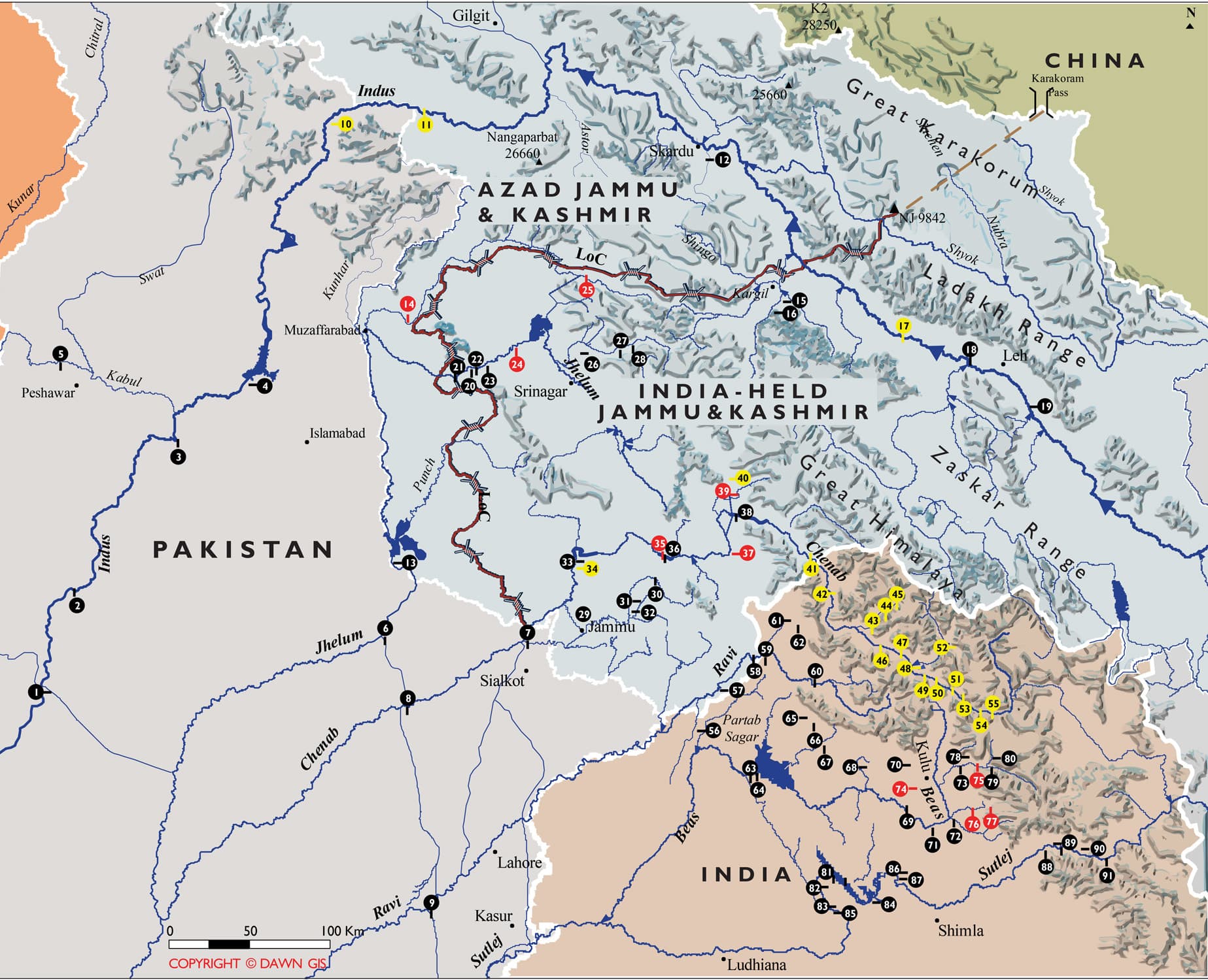
Jhelum River is a river that flows in Kashmir and Pakistan. It is a tributary of the Chenab River and has a total length of about 480 miles (774 kilometers). The river Jhelum rises from a spring at Verinag situated at the foot of the Pir Panjal in the south-eastern part of the valley of Indian held Kashmir. It flows through Srinagar and the Wular lake before entering Pakistan through a deep narrow gorge. The Kishenganga (Neelum) River, the largest tributary of the Jhelum, joins it, at Domel Muzaffarabad, as does the next largest, the Kunhar River of the Kaghan valley.
Dams and barrages on Jhelum
Water control structures are being built as a result of the Indus Basin Project, including the following:
- Mangla Dam, completed in 1967, is one of the largest earth fill dams in the world, with a storage capacity of 5.9 million acre-feet (7.3 km³)
- Rasul Barrage, constructed in 1967, has a maximum flow of 850,000 ft³/s (24,000 m³/s).
- Trimmu Barrage, constructed in 1939 some 90 km from Mari Shah Sakhira town, at the confluence with the Chenab, has maximum discharge capacity of 645,000 ft³/s (18,000 m³/s).
- Harahpur (Victoria Bridge) Constructed in 1933 approximate 5 km from malakwal near Chak nizam Village.
Chenab River
Chenab River provides water to 21 canals and irrigates about 7 million acres of agriculture land in Punjab. The average annual flow of waters in the eastern rivers is estimated to be around 33 Million Acres Feet (MAF) whereas it is 135 MAF in the western rivers.
Indus River
Indus River has a total length 3,180 kilometres from Tibet and to Arabian Sea. It runs 404 km in China and 395 km in Ladakh.
Ravi River
Indian Dams in Kashmir
Baglihar Dam
Baglihar Dam also known as Baglihar Hydroelectric Power Project is a run-of-the-river power project on the Chenab River in the southern Doda district of the Indian administered state of Jammu and Kashmir. This project was conceived in 1992, approved in 1996 and construction began in 1999. The project is estimated to cost USD $1 billion. The first phase of the Baglihar Dam was completed in 2004.
Run-of-the-river hydroelectricity is a type of hydroelectric generation whereby the natural flow and elevation drop of a river are used to generate electricity. Power stations of this type are built on rivers with a consistent and steady flow, either natural or through the use of a large reservoir at the head of the river which then can provide a regulated steady flow for stations down-river (such as the Gouin Reservoir for the Saint-Maurice River in Quebec, Canada).
Dulhasti Hydroelectric Project
Dulhasti is a 390 MW electricity power station in Kishtwar district of Jammu and Kashmir. It is a run-of-the-river scheme which will produce 390MW of power. The project is constructed on river Chandra, a tributary of river Chenab. The project headquarter is located at Kishtwar in district Doda of J&K. The concrete gravity dam is situated in village Dul and the Power house is located in village Hasti.
Salal Hydroelectric Project
Salal Hydroelectric Power Station Stage-I of 345 MW (115X3) and Stage-II of 345 MW (115X3) are being constructed on river Chenab in Dhyangarh Tehsil Reasi the state of Jammu & Kashmir. The project was conceived in 1920.
Technical features
- 118 m high, 630 m long rockfill dam.
- 113 m high, 450 m long concrete dam
- Sub-surface power house containing 6 units of 115 MW each.
Concrete Dam
- Max height : 113 m
- Length of top : 450 m
- Full Reservoir level : 487.68 m
Uri Hydroelectric Project - I & II
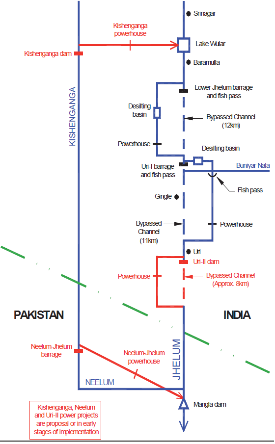
Uri hydel is a 480 MW hydroelectric power station on the Jhelum River near Uri in Baramula district of Jammu and Kashmir, India. It is located very near to the Line of Control, the de-facto border between India and Pakistan. The station is largely built under a hill with a 10 km tunnel. It is of the run-of-the-river type without a large dam, since the Indus Waters Treaty gives Pakistan the exclusive right to regulate the Jhelum River.
Nimoo Bazgo Project
The Nimoo Bazgo power project is situated at village Alchi, 70 kilometers from Leh and the construction work is at full swing. Initially, 45 megawatt of electricity would be generated by constructing 57-metre high concrete dam on the Indus River. Excavation work for the powerhouse is 100% complete and 48% concreting for dam up to crest level has also been completed.
Dumkhar Project
Dumkhar project, a 42-meter high dam, will generate 130MW of electricity. The project site is located at about 128km from Leh on Leh-Khalsi Batalik road.
Chutak Dam
Chutak Hydroelectric Project would harness the hydropower potential of river Suru in Kargil district of Jammu & Kashmir. It has a capacity of 44MW and height of 59m. The barrage of the project is located near Sarzhe Village and the power house will be located on the right bank of river Suru near Chutak Village. The project is a run-of-river hydro project.
Kishanganga Hydropower project
The proposed Kishanganga Hydroelectric Project would be located on river Kishanganga, a tributary of river Jhelum, in Baramulla district of Jammu & Kashmir. The project involves construction of a 37m high concrete faced rock fill dam and an underground powerhouse. A maximum gross head of 697 m is proposed.
Pakal-Dul Dam
Pakal Dul (Drangdhuran) Hydroelectric Project is a reservoir based scheme proposed on river Marusudar, the main right bank tributary of river Chenab in Kishtwar District in Jammu & Kashmir. The Project is a concrete face rockfill dam and an underground Powerhouse at a location 2 km u/s of Dul dam, near village Trimuli. At Full Reservoir Level (EL 1700 M), the gross storage of the reservoir is 125.4 Mil.cu. m.
Bursar Dam
The proposed dam would have 829 feet height, storage capacity of more than two million acres feet and power generation capacity of 1200MW. The height of Baglihar, Tarbela and Mangla Dam is 474, 485 and 453 feet, respectively. Bursar Dam would be constructed near Hanzal Village (near Kishtwar) in Doda District of Jammu & Kashmir on the 133-kilometre-long Marusudar River, the main right bank tributary of the Chenab river.
Overall Impact of Indian Dams in Jammu & Kashmir on Pakistan
India is busy building dams on all rivers flowing into Pakistan from occupied Kashmir to regain control of water of western rivers in violation of Indus Treaty. This is being done under well thought out strategy to render Pakistan’s link-canal system redundant, destroy agriculture of Pakistan which is its mainstay and turn Pakistan into a desert. India has already built 14 hydroelectric plants on Chenab River and is building more plants which will enable it to block entire water of Chenab for 20-25 days. These dams have also enabled India to release huge quantity of water downstream not only to cause damage to standing crops but also to our canal systems. Chenab River provides water to 21 canals and irrigates about 7 million acres of agriculture land in Punjab province of Pakistan.
According to the latest study titled ‘Mountains of Concrete: Dam Building in the Himalayas’, Pakistan is on the brink of water disaster and its availability would plunge to 800 cubic meters per capita annually by 2020 from the current 1,200 cubic meters. Just 60 years ago, 5,000 cubic meters of water was available to every Pakistani citizen.
In worst case scenario, agriculture and electricity aside, Indian blockade of Pakistani water will tear apart Pakistani social fabric as there will be a severe reduction in productivity and millions of people will be deprived of food and water. Riots in large cities and towns may erupt and this would jolt the law and order situation in the country. Such incidents with less intensity have already taken place in Pakistan against constant load-shedding of electricity. Trains and infrastructure was set on fire in some cities, roads were blocked in other and thousands of employees lost their jobs.
- The Indian move could prove disastrous for Pakistan.
- India has already constructed 50-60, medium-sized projects and it plans more than a hundred. One hundred and fifty will be in the small catchment areas in Occupied Jammu and Kashmir.
- Many trees will be cut, and the resulting environmental impact will also impact Pakistan’s water, due to the environmental degradation and increased sediment flow.
- Already, we are facing a shortage in the western rivers, how can we then compensate for the lack of water in the eastern rivers?
- India’s dam-failure record has been worst, as nine of its dams have so far collapsed,” the latest failure was Jaswant Sagar Dam of 43.38 meters height that collapsed in July 2007.
- the team stated that the BHP would deprive Pakistan of 26 to 28 per cent water in winter season thereby affecting Pakistan's irrigation water requirements especially during the Rabi crop season
- Another crisis in the making is the Kishanganga hydroelectric project on the Neelum River in India. The average flow of Neelum water will drop by 21 per cent in Pakistan, which will not only cause energy losses amounting to billions of rupees but also serious environmental damage. In due course, India will have the ability to damage Pakistan's resources.
- These dams have also enabled India to release huge quantity of water downstream to not only cause damage to standing crops but also to our canal systems.
- The reduced water inflows would bring about huge loss to cropped areas of Punjab, besides causing early depletion of Mangla Dam.
Unlike India, Pakistan is highly dependent on agriculture, which in turn is dependent on water. Without any doubt, almost 80% of Pakistan’s agriculture is dependent on irrigation. Many of Pakistan’s industries are agro-based such as the textiles industry. Moreover, 70% of Pakistan’s food needs are fulfilled domestically. 
Individual Impact of Indian Dams in Kashmir on Pakistani Rivers
Baglihar Dam
Storage of water in Baglihar Dam reduced the flow of water in Chenab River during the sowing period of August to October 2008 and badly affected the agriculture sector of Pakistan. Pakistan lost 23000 cusecs of water; farmers could not irrigate their fields due to shortage of water and resultantly 3.5 million agriculture tracts got barren. The standing cotton, paddy crops of basmati rice of Kharif season in Punjab which were ripe got badly affected because of absence of water.
The treaty restriction on storage also required that India not build gates for flushing silt out of its dams. This meant that any Indian dam on the Chenab and the Jhelum rapidly fills with silt. India used this feature as an argument in favor of Baglihar Dam before the Neutral Expert appointed by the World Bank. Deciding in favor of Pakistan on three issues, the Neutral Expert ruled in favour of India on the fourth: building of gates. Pakistan is thus left without a mechanism for protection against manipulation of flows by India. When India chose to fill Baghliar it did that exactly at a time when the filling caused the maximum damage to Pakistani farmers.
Dul Hasti Hydroelectric Project
Salal Hydroelectric Project
Constructed on the Chenab River
Uri Hydroelectric Project - I & II
Pakistan had earlier raised objections over the 240 MW Uri-II project being constructed on Jhelum river in Kashmir valley and the 44 MW Chutak plant being built on Suru, a tributary of Indus river
Nimoo Bazgo Project
Nimoo Bazgo, Dumkhar & Chutak dams can store water up to 120,000,000 cubic meters. India is spending Rs 6.11 billion just to produce 45 MW electricity and that would only possible when power station works on full capacity which is not possible in winter when glaciers stop melting. The more interesting thing to note here is Indian contractor (NHPC) never released any data on its website regarding capacity of the reservoir and type of spillways which is really disturbing as any gated spillways on Indus would enable India to block every drop of water flowing into Pakistan.
Dumkhar Project
Dumkhar project, a 42-meter high dam, will generate 130MW of electricity. The project site is located at about 128km from Leh on Leh-Khalsi Batalik road.
Dumkhar HE Project is proposed to generate 130 MW by construction of 42-meter high dam. The project site is located at about 128 Km from Leh on Leh-Khalsi Batalik road. And Hydroelectric Project “Chutak” is under construction on River Suru, (a major tributary of Indus River in Indian held Kashmir) to harness 44 MW initially in Kargil district by construction of 59-metre-high concrete Dam. Failure of Banqiao dam in China in August 1975 caused a 10 km wide and up to 23 ft high wave rushing downwards to the plains at nearly 50 km per hour killing 26,000 people from flooding and another 145,000 from subsequent epidemics and famine.
Chutak on River Suru
Chutak is under construction on River Suru. In case any of these dams collapse or large quantity of water is deliberately released, it will not only endanger our proposed Bhasha dam but also submerge Skardu city and airport. KKH between Besham and Jaglot would wash away.
Kishanganga Hydropower project
Pakistan had protested the construction of the Kishanganga project earlier this year, arguing it would adversely affect 133,209 hectares of agricultural land in Azad Jammu and Kashmir. Despite Pakistan’s objections, the Indian government has been successful in completing the Baghlihar Dam, having a 474m height and water pondage capacity of 37.5 million cubic meters, because the authorities in Islamabad reacted too late, when the project had reached an advanced stage. The Project is proposed to be completed by January 2016.
Baghlihar Dam can block 7000 cusecs of water per day whenever India wishes to. Indian project would divert the River Neelum to Wullar Lake, leaving very little water for the Pakistani project, which is just 70 kilometers downstream from the Indian Kishanganga project.
The Controversy: The proposed scheme envisages diversion of the Neelum waters into the Jhelum through a 21-km long tunnel to produce 330 MW power. The powerhouse will deliver the water through a nullah into the Wullar Lake. Pakistan has been opposing the project on account of its adverse effects for Pakistan’s own hydroelectric project in Azad Kashmir on the Neelum-Jhelum River. It has been estimated that with Indian implementation of the project, a shortfall of about 21% of the Neelum flow is likely to reduce the power potential of Neelum-Jhelum Link Hydroelectric Project (NJHP) by 9.25%.
For Pakistan it is a matter of survival, once control over Neelam lost life of Mangla dam would be at risk and the entire investment made on Neelam-Jehlum project will also be wasted. According to the Indus Water Treaty, the project commissioned first would be accorded top priority. In the case of Pakistan, this would likely mean that the Neelum-Jhelum project would have to be abandoned, as the Kishanganga project would leave very little water for Pakistan to use.
Kirthai Dam
India has already built 14 hydroelectric plants on Chenab River and is building more plants which will enable it to block entire water of Chenab for 20-25 days. These dams have also enabled India to release huge quantity of water downstream to not only cause damage to standing crops but also to our canal systems.
Sawalkot Dam
The Sawalkot project is located in Doda and Udhampur districts of occupied Kashmir. The most crucial and the biggest of the five dams is the Sawalkot project with a capacity of 1,200 MW. The Sawalkot dam would be highly vulnerable to earthquake being in the seismic zone of Kashmir Himalayas which could be an environmental disaster for Pakistan as the lower riparian.
Riparian Zones are those areas which lie at the banks of a canal or a river or downstream of the water channel and residents of the area possess priority rights for the use of water of that channel, except otherwise stated in regional or international treaties. Pakistan is a riparian of Indus System rivers, as it is situated at downstream of the river.
But the most crucial and the biggest is the Sawalkot project with a capacity of 1,200MW. Indian documents reveal that the Sawalkot Dam project on the Chenab in occupied Kashmir has 646-foot height, which is more than the 485-foot height of Tarbela and 453-foot of Mangla. The project is also higher than the Baghlihar Dam and has 13 times more water capacity. It renders Pakistani rivers vulnerable to water shortage by India, because India has done this practice several times and does not let slip away any opportunity of damaging Pakistan, through any means.
Pakal-Dul Dam
The most crucial and the biggest is the Sawalkot project with a capacity of 1,200MW. Another is the 1,000MW Pakul Dul project for which Rs51 billion has been allocated and the executing agencies are awaiting forest clearance of 311 hectares and security arrangements to start construction. Environmentally, this project can prove to be an ecological disaster as most of its submerged area will consist of forests and agriculture lands. Submergence of forest land leads to loss of biodiversity and habitat destruction of wildlife on the other hand submergence of agriculture land as well as dwelling require rehabilitation of ousted people.
Bursar Dam
It is constructed on Marusudar River in Doda District. Its construction would be a serious violation of the treaty as its storage was much behind the permissible limits. More than 4900 acres of thick forest would be submerged and the whole population of Hanzal village would be displaced.
The project area is in Seismic Zone V and hence most vulnerable to earthquake. Two active geological faults lines — Himalayan thrust and the Kishtwar fault — are passing through the project area, the worst impact of dam would be on glaciers of Marusudar river basin and hence the Pakistani Rivers. Deforestation, coupled with high altitude military activities, had already created 48 glacial lakes in the Marusudar river basin covering an area of 225.35 sq km and massive construction activities in basin would further aggravate the melting of glaciers. This dam will also store water and hence blocking entire water of Chenab in winter season when Pakistani farmer sow wheat.
Steps Needed to be taken by Pakistan
- One of the most water-stressed countries in the world, Pakistan faces a situation threatening into grave water shortage. Direct rainfall contributes less than 15 per cent of supply of water to crops. Of the cultivatable areas of almost 77 million acres (MA), only 36 MA are canal-irrigated. Pakistan has the additional potential of bringing about 22.5 MA of fallow land under irrigation.
- An average of 35.2 million acre feet (MAF) of water escapes beyond Kotri every year, mostly in the rainy season. With their flow patterns variable, Pakistan's rivers have higher discharges in summer and lower discharges in winter. Pakistan's dependence on a single river system means that it has fewer choices than countries with a multiplicity of water sources. Therefore, construction of additional water storage facilities is critical for the conservation and utilization of water.
- By 2013, Tarbela, Mangla and Chashma, which are rapidly losing their storage capacities because of sedimentation, will have lost almost one-third of their original potentials. This virtually means loss of one mega-reservoir. Creation of more reservoirs is an absolute essential also if Pakistan is to meet the additional allocations required under the 1991 Water Accord between the provinces.
- The solution to Pakistan's water problems has two aspects: how the country can utilize its own potential, and how its potential can be affected by India.
- Two things should be done immediately: the World Bank arbitration process should be reactivated, and the pace of work at Neelum-Jhelum should be significantly increased. India is already doing that at the Kishanganga project.
- Pakistan's water issues with India are about as important as the resolution of the Kashmir problem. In fact, the two are interlinked. Therefore, the resolution of the water issue should be part and parcel of any process of normalization between India and Pakistan.
- Pakistan has to invest soon in new large dams. WAPDA's Vision 2025 should be pursued on a priority basis, under which four storage reservoirs, Yugo, Skardu, Basha and Kalabagh, are planned. One storage reservoir (at least) is urgently needed merely to make up for the dams' capacities lost to sedimentation. As for the years beyond 2025, Pakistan should start focusing on other storage sites. There are many on the Indus and the Jhelum and off-channel. There are also hundreds of small and medium storage sites in all the four provinces, work on which must be pursued. At the same time, the enormous backlog of maintenance work on our water infrastructure must be taken in hand.
- The use of TBM has remained limited in the past due fear of impact of drilling on weak geological formations. However, in the past decade tremendous improvements in tunneling technology have been achieved, removing the fears associated with use of TB. So tunnel boring machines should be used by WAPDA in Pakistan and increase the speed of construction of Neelum-Jhelum Project.
- We will now have to look beyond the Indus Water Treaty for solutions. India is allowed run-off hydro-electric projects according to the treaty, but two or three is different from more than a hundred.
- Currently, Pakistan has 40,000 MW hydro Power potential on river Indus alone while combined estimate of whole Indus basin river system surpasses the figure of 70,000 MW. But unfortunately only 5000 MW is being produced at the moment which is merely 12.5% of total potential.


