Surveying Dictionary Words Definitions Starting from E, F, G


Easement
The right, privilege or liberty given to a person or group to use land belonging to another for a specific and definite purpose e.g. the right given to an electricity company to bring electricity transmission lines across a private property.
Easting
Coordinate value by longitudinal reference.
Earth Resources Technology Satellite
This was later renamed Landsat.
Electronic Distance Measurement, EDM
EDM is a relatively new technique that is still evolving and improving. It was first introduced in 1948 by Swedish physicist Erik Bergstrand. His device used visible light and could accurately measure distances up to 25 miles at night. First introduced in 1957, microwave instruments can be used day or night.
Current devices are either electro-optical instruments, which use laser or infrared light, or microwave instruments. The former requires a passive reflector at the opposite end of the line, while the latter method requires two identical instruments. Refer to the texts for more information on EDM.
Electronic Distance Measuring Equipment
This instrument measures distances using light or sound waves.
Elevation
The height above mean sea level.
Encumbrance
Restrictive real property interest or right.
Ephemeris
A description of the path of a celestial body indexed by time (from the Latin word ephemeris meaning diary). The navigation message from each GPS satellite includes a predicted ephemeris for the orbit of that satellite valid for the current hour. The ephemeris is repeated every 30 seconds and is in the form of a set of 16 Keplerian-type parameters with corrections that account for the perturbations to the orbit caused by the earth's gravitational field and other forces.
Equator
Standard parallel of 0 degrees latitude.
Exterior Angle
Exterior angle formed by intersecting lines of an polygon or land parcel boundaries.
Face
A surface bounded by a closed sequence of edges. Faces are contiguous and fill the spatial extent of the dataset and do not overlap.
Farmsteads and ranch headquarters
A Land cover/use category that includes dwellings, outbuildings, barns, pens, corrals and feedlots next to buildings, farmstead or feedlot windbreaks, and family gardens associated with operating farms and ranches. (Commercial feedlots, greenhouses, poultry facilities, overnight pastures for livestock, and field windbreaks are not considered part of farmsteads.)
Field
A specified part of a record containing a unit of data.
Field Books
Field books are standard forms for recording of survey data as it is collected. There are different types of field books that are common for different types of surveys. The pages of a field book are typically numbered in pairs, i.e., the left and right pages that face each other are given one number and are considered as a unit containing related information. The left side of the 'page' is usually ruled into six columns (some books have eight columns). The right 'page' usually looks like a sort of graph paper. This is where most of the differences occur. Various types are: transit, engineer's, cruisers, leveling, etc. (Look at a catalog like Forestry Supply or Ben Meadows for details.)
Field Notes
Field notes are a permanent record of field procedures and the data collected in those procedures. Field notes should be made carefully. It is a common tendency to crowd information onto the pages. Data can now be found.
Forest land
A Land cover/use category that is at least 10 percent stocked by single-stemmed woody species of any size that will be at least 4 meters (13 feet) tall at maturity. Also included is land bearing evidence of natural regeneration of tree cover (cut over forest or abandoned farmland) and not currently developed for nonforest use. Ten percent stocked, when viewed from a vertical direction, equates to an aerial canopy cover of leaves and branches of 25 percent or greater.
Foresight
A foresight is a reading taken on a position of unknown coordinate(s). Since a survey progresses from a point of known position to points of unknown position, a foresight is a reading looking "forward" along the line of progress. Foresights may be taken on the "main circuit" of the survey or on additional points of interest. Readings on additional points of interest are sometimes called sideshots or intermediate foresights to distinguish them from the readings that form the main circuit of the survey.
Footprint
The ground area occupied by an object e.g. a building.
General cover
Nine general cover categories are defined, based upon vegetative structure (e.g., canopy cover percentage) or substrate characteristics (e.g., barren land/artificial surfaces). They are: Crop; Herbaceous; Open canopy short woody plants; Short woody plants; Open canopy tall woody plants; Tall woody plants; Barren; Artificial and modified surfaces; Water. See also Habitat composition and Habitat configuration.
Geocentric datum
A datum which has its origin at the Earth's centre of mass. This datum can therefore be used anywhere on the planet and be compatible with the same datum anywhere else on the planet.
Geodesy
The science and mathematical calculations of the shape and size of the Earth.
Geographical coordinates
A point on a map given as latitude and longitude readings. The values are given as degrees, minutes and seconds.
Geographic Information Systems
GIS is the spatial capture of themed data layers and the storing, analysing and displaying of the geographically referenced information. A GIS also includes the procedures, software, hardware, operating personnel and spatial data associated with the system.
Geocode
The element in a database used to identify the location of a particular record e.g. a postcode. The process of geocoding is similar to that of address matching in that a data file is compared against a file of geocode and their associated coordinates.
Geodata
Information that identifies the geographical location and characteristics of natural or man-made features and boundaries of the earth. Geodata represent abstractions of real world entities such as roads, buildings, vehicles, lakes, forests and countries.
Geodemographic Data
Statistical population data, or demographic data, with a spatial reference. For example, census information based upon enumeration districts. This is a type of map data.
Geodetic Datum
A set of parameters defining coordinate systems for all or parts of the earth. These data have been refined and revised over time e.g. NAD 27 is the North American datum for 1927, ED50 is the European datum for 1950 and WGS is the World Geodetic System for 1984.
Geographic Information
Information about objects or phenomena that is associated with a location relative to the surface of the earth. A special case of spatial information.
Geographical Information System
A system for capturing, storing, checking, integrating, analysing and displaying data that is spatially referenced to the earth. This is normally considered to involve a spatially referenced computer database and appropriate applications software.
Geoid
An imaginary shape for the earth defined by mean sea level and its imagined continuation under the continents at the same level of gravitational potential.
Geoidal Height
The height of a point on the geoid above on ellipsoidal reference surface.
Geometric Data
Data about position within an absolute or relative coordinate system.
Geospatial Data
Another term used to describe Map Data but commonly isn't directly associated with a map e.g. an address has a spatial reference associated with it but not in map coordinates.
Global Positioning System
GPS is a satellite based navigation system originally developed by the United State's Department of Defence. A GPS receiver calculates a position by measuring distances to four or more satellites of a possible 24. These orbit the Earth at all times.
Graphical User Interface
A method of interaction with a computer which uses pictorial buttons (icons) and command lists controlled by a mouse. It is generally regarded as simpler and easier to learn than command line interfaces, where commands have to be typed. Examples include MS WINDOWS for PCs, Open Look or MOTIF for workstations and System 7 for Macintosh.
Grid
A group of parallel lines that run perpendicular to another group of parallel lines to form a map coverage of squares.
Grid coordinates
A point on a map given as an easting and northing reading. The values are given in metres.
Grid north
The direction of the vertical grid lines shown on a topographic map. The difference between grid north and true north is referred to as grid convergence.
Ground Height
The height where the building wall intersects the ground.
Ground Station
A facility capable of receiving signals from earth observation satellites such as LANDSAT, SPOT, ERS, JERS AND MOS.
Growing season
The period and/or number of days between the last freeze in the spring and the first frost in the fall for the freeze threshold temperature of the crop or other designated temperature threshold.
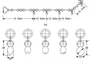
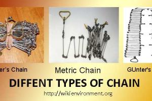
Gunter's chain
A distance measuring device composed of 100 metal links fastened together with rings. The length of the chain is 66 feet. It was invented in about 1620 by English astronomer, Edmund Gunter.